Geolocation
You can search for properties near a specific location by using the geolocation filter. This filter takes latitude, longitude, and range parameters to search for matching properties within a circular boundary around a coordinate.
The format for a geolocation filter is: [Longitude,Latitude,Distance,Distance Unit].
longitude- longitude of the point where you want your radial search to start from.latitude- latitude of the point where you want your radial search to start from.Distance- integer value of the radius of the search.Distance Unit- unit of measurement the distance value represents.
Here's an example:
{
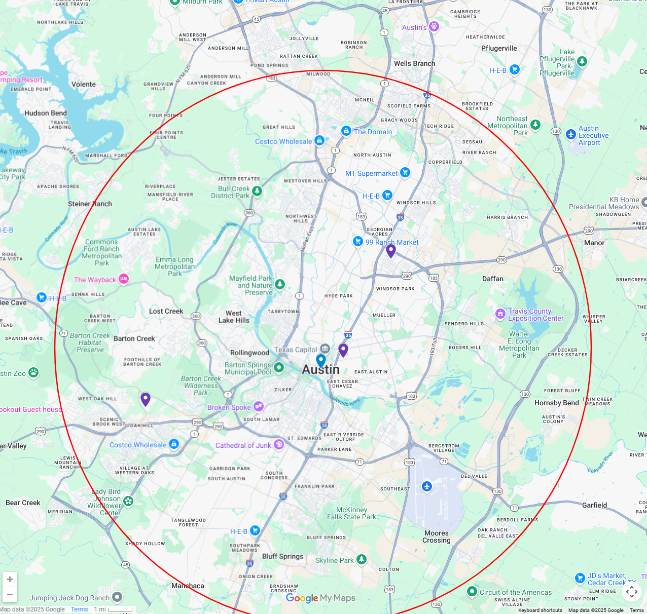
  "query":"geoLocation:[-97.7430600,30.2671500,10,mi]",
  "view":[
    {"name": "address"},
    {"name": "city"},
    {"name": "country"},
    {"name": "mostRecentStatus"},
    {"name": "mostRecentStatusDate"},
    {"name": "mostRecentStatusFirstDateSeen"},
    {"name": "postalCode"}
  ]

}
For sale vs rental statuses
Please note that Datafiniti tracks for sale and rental statuses separately, so if you are looking for rental statuses please use mostRecentRentalStatus. Being to check the possible status value here. Possible Values for Property Fields
An example from the response:
{
    "num_found": 634663,
    "total_cost": 3,
    "people_cost": 0,
    "property_cost": 3,
    "business_cost": 0,
    "product_cost": 0,
    "records": [
        {
            "address": "7311 Providence Ave Unit A",
            "city": "Austin",
            "country": "US",
            "latitude": "30.331404",
            "longitude": "-97.695693",
            "mostRecentStatus": "Pending",
            "mostRecentStatusDate": "2025-05-28T00:00:00.000Z",
            "mostRecentStatusFirstDateSeen": "2025-06-05T10:17:12.176Z",
            "postalCode": "78752",
            "id": "6TNwIXIBA7mjcpg9WxOh"
        },
        {
            "address": "6636 W William Cannon Dr Unit 1123",
            "city": "Austin",
            "country": "US",
            "latitude": "30.244474411",
            "longitude": "-97.861640930",
            "mostRecentStatus": "Rental",
            "mostRecentStatusDate": "2025-06-20T10:01:14.376Z",
            "mostRecentStatusFirstDateSeen": "2025-06-20T10:01:14.376Z",
            "postalCode": "78735",
            "id": "uc3J8JAB3hcw0YbIkz88"
        },
         {
            "address": "1211 E 13th St",
            "city": "Austin",
            "country": "US",
            "latitude": "30.273210",
            "longitude": "-97.727720",
            "mostRecentStatus": "For Sale",
            "mostRecentStatusDate": "2025-05-26T00:00:00.000Z",
            "mostRecentStatusFirstDateSeen": "2025-06-09T19:53:54.412Z",
            "postalCode": "78702",
            "id": "3CYhpHIBzUQvJ7ofBJwQ"
        },
    ]
}
As you plot your result on a map you will see that the records returned are within a radius generated by the geolocation search.

Units of measurement
You can use the following units for measuring distance:
m - meters
mi - miles
ft - feet
in - yards
mm - millimeters
km - kilometers
NM - nautical miles
cm - centimeters
Use cases
Check out some of our use cases that use geoLocation:
Updated 6 months ago
